
Some frequently asked surveying questions are:
- How much should I expect to pay for a boundary survey of my property?
- Why did two different surveyors come up with two different boundary results for my property?
- Who can write a legal description in Oklahoma?
- What does the term “Section” actually mean in the surveying world?
- What is an elevation certificate?
1 – How much should I expect to pay for a boundary survey of my property? A – Price varies greatly for many reasons, but the 2 main reasons are how your property’s legal description is written and the availability of “controlling corners” for your legal description. If you own land in a fairly new subdivision then a surveyor can expect to go find many of the original subdivision corners that are undisturbed and correctly placed. Finding and using these undisturbed corners allows the surveyor to know where your property corners should be. Therefore, the price will be much less (350 – 550 dollars). If your legal description is written in such a way that the surveyor must survey most or all of the section (mile by mile square that is the basis of land descriptions in Oklahoma), then you can expect to pay much more (starting at about 1,000 dollars and going up from there). Other factors that can affect price are tree cover (especially on the property lines), property accessibility, and if the property adjoins a body of water that will require special boundary retracing. Property located in old subdivisions can also be more expensive to survey due to the lack of original subdivision corners that can be found in the field.
2 – Why did two different surveyors come up with two different boundary results for my property? A – Surveying is an inexact science and is based on the original government survey of Oklahoma Territory that took place from 1870-1895 or so. The original surveyors did their best to divide Oklahoma into mile by mile squares called “sections” and even though they did a very good job overall, you can imagine that sections weren’t exactly one mile by one mile square. Over the years the original monuments that they used to mark the section corners (stones and wood posts) have deteriorated or have been destroyed by roads, fences, and land use. When an original section corner monument is no longer in existence, a surveyor does his/her best to restore it to its original location, but this can be very difficult because of the lack of information of its original position. Surveyors often disagree on where the monument was originally, and so they may place multiple new corner monuments where a single corner used to exist. Depending on which corner placement the subsequent surveyors choose to use, your legal description can be staked out differently. For example if there are two corner monuments at the northwest corner of the section that you live in (one monument 5 feet east of the other) and your legal description uses the northwest corner of the section as a reference to where your property lies, then one surveyor might lay out your property lines 5 feet east from where another surveyor might lay them out, depending on which section corner they feel is most nearly correct. Boundary questions can be very complicated due to poorly written legal descriptions and owner disputes. It is important for one to realize that there is no overall database that tells surveyors where the property corners should be, and despite the incredible advances in measuring technologies (GPS, Total Station measuring, etc.) it is still up to the surveyor to determine how all of the legal descriptions should fit together and where the corners should be placed.
3 – Who can write a legal description in Oklahoma? A – There is no law in Oklahoma preventing anyone from writing a legal description of property. While this is a good thing from a self reliance standpoint, you should use caution if you or anyone else that is not a well practiced surveyor is attempting to write a legal description that will be used to convey property. There are many reasons for this, but one of the most common fallacies is trying to describe a piece of property based off of the assumption that the mile by mile section that it is contained in is, in fact, exactly one mile by one mile, with 90 degree corner angles. No such section exists and it never will. Therefore, if the actual measurements of the section are slightly less than a mile then the legal description that assumes a perfect mile will result in overlapping property lines with the adjoining descriptions. Conversely, if the actual section measurements are greater than a mile then you are left with gaps between legal descriptions. You can imagine the terrible mess that this leads to, but it is a very common problem. It is my recommendation that you have a surveyor provide you with legal descriptions of property so that problems like this can be avoided or at least dealt with properly if they already exist.
4 – What does the term “Section” actually mean in the surveying world? In the context of property boundaries the term “Section” generally means a tract of land that is nearly 1 mile square (5280 feet x 5280 feet). Now, I need to explain 2 of the words I used in the previous statement, “generally” and “nearly”. First, the reason I say that a section is “generally” thought of as one square mile is because not all lands in the United States were divided into these one mile squares. For land ownership to be orderly and transferable there needed to be a consistent way of describing real property in words, so a system called the Public Land Survey System was devised to accomplish this. This system was originally proposed by Thomas Jefferson after the Revolutionary War and through a series of federal land acts, it was put into action starting in about 1785. 30 of the 50 United States use the Public Land Survey System as a means of subdividing and describing land (map of states that use this system http://nationalmap.gov/small_scale/a_plss.html). Most of the Eastern United States and Texas were not subdivided using this method, so the term “Section” will not mean the same thing in those states. States that were originally surveyed using the Public Land Survey System were first divided into larger squares called townships. These townships were intended to be 6 miles square, containing a total of 36 sections (36 square miles). After the township boundaries were established, the interior of the township was divided into the 1 mile square “sections” mentioned above. Each section has an associated number, 1-36, as seen below.
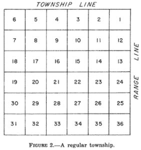
This pattern of numbering is the same in every township, so for example, one always knows the position of say Section 15 in the township, no matter what the township is.
Now that you have a better idea of the meaning of the term “section”, let’s focus on that second term I mentioned, “nearly”. As I said earlier, the subdivision of lands using the Public Land Survey System started around 1785. You can imagine that people’s means for accurately measuring land were quite limited during those early days. In fact, our tools used for accurately measuring land didn’t change a whole lot until the 1970s when electronic distance meters started being used. Since the 1970s our means for measuring land have changed quickly and dramatically. Surveyors can now measure out a mile using a survey grade GPS system that produces measurements that are accurate to within 1 centimeter! Anyway, I say all of that so that you can get an idea of the error that is involved in the original surveys that control our current property boundaries. The original surveyors used a tool called a chain that was 66 feet long. 80 chains equals 5280 feet, or 1 mile. Due to terrain, vegetation, and human error, none of the sections turned out to be exactly 1 mile square, but no matter how much error the original sections contained the original survey is presumed correct and binding. What this means is even if the original surveyors lost count of how many chains they had measured and the mile turned out to be 66 feet short, that is what we use for the boundaries of the section. There is no “fixing” the original survey. It is what it is, and we live within its bounds. I am amazed at how close those early surveyors got at times, but the fact remains that there is no such thing as a perfect section (perfect 1 mile x 1 mile square). So, the best we can say is that each section is “nearly” one square mile.
One last interesting fact before we go; these original surveyors had a way of dealing with the error that would build up in the course of subdividing a township into sections. They did their best to measure out square miles and then when they arrived at the very northern most 1/4 mile of the township and the western most 1/4 mile of the township they would allow that 1/4 mile to absorb all of the excess or deficiency that existed. So, the northern most and western most quarter mile measurements may vary anywhere from 100 to 800 feet longer or shorter than an actual 1/4 mile measurement of 1320 feet. There, now you know just a little bit more about the survey term “Section”.
5 – What is an elevation certificate? An elevation certificate is a surveying product that will determine the elevation (above sea level) of the lowest floor of the dwelling on which it is performed. The form that a surveyor fills out and presents to the client as the final product is issued from FEMA (Federal Emergency Management Agency) (https://www.fema.gov). FEMA maintains a database of maps that they call FIRMs which stands for Flood Insurance Rate Map. Use this link to see what FIRM shows your property (https://msc.fema.gov/portal). These maps show areas that are prone to flooding. In populated areas, these FIRMs will also show cross section lines along the flood prone areas that represent the base flood elevation at that cross section. The base flood elevation is FEMA’s best estimate of how high the water might get during a “100-year flood” event. The criterion for this event are determined by past rainfall amounts and the likelihood of a certain amount of rain falling in a certain amount of time. If you are borrowing money to build or buy a structure, then the lender will look at the property that you want to purchase on the applicable FIRM. If your property touches any part of the flood prone area, then the lender will most likely require flood insurance. You can sometimes avoid purchasing flood insurance if an elevation certificate from a licensed surveyor shows the bottom floor of your structure is above the base flood elevation. Being able to avoid the requirement for flood insurance will, obviously, save the owner a lot of money. If the lowest floor of the structure is not above the base flood elevation then the property will be harder to insure against flooding, or possibly disqualify it from being insurable. An elevation certificate should cost around 450 dollars. The surveyor is required to determine several elevations on the property, provide details about the construction of the dwelling, and take pictures of certain views of the dwelling.
– Micah Gustin, Oklahoma Licensed Surveyor #1769